
State Planner

Ohio · October 27, 2026

ODOT Geotechnical Bore Holes by County

This is a real answer State Planner produced from Ohio’s public data.

Ask this question, or one like it, in State Planner now. Sign up to try every feature free for 7 days, no card needed, and the question will be waiting in your new chat to change or send.

Ask this in State Planner →
  1. ODOT Geotechnical Bore Hole Locations by County

    The county name field is inconsistent (mixed case, abbreviations, typos), so I'll assign each boring to a county by its location instead.


    ODOT geotechnical bore holes by county

    The table holds 277,379 ODOT test borings, going back to the 1920s. Its county name field is messy, with mixed case, abbreviations like "FRA" and "HAM", and typos such as "HAMITON". To get clean counts, I placed each boring in a county by where it sits on the map, using ODOT's county outlines. That covers 277,204 borings. The other 175 fall just outside the state line, mostly along the Ohio River and Lake Erie.
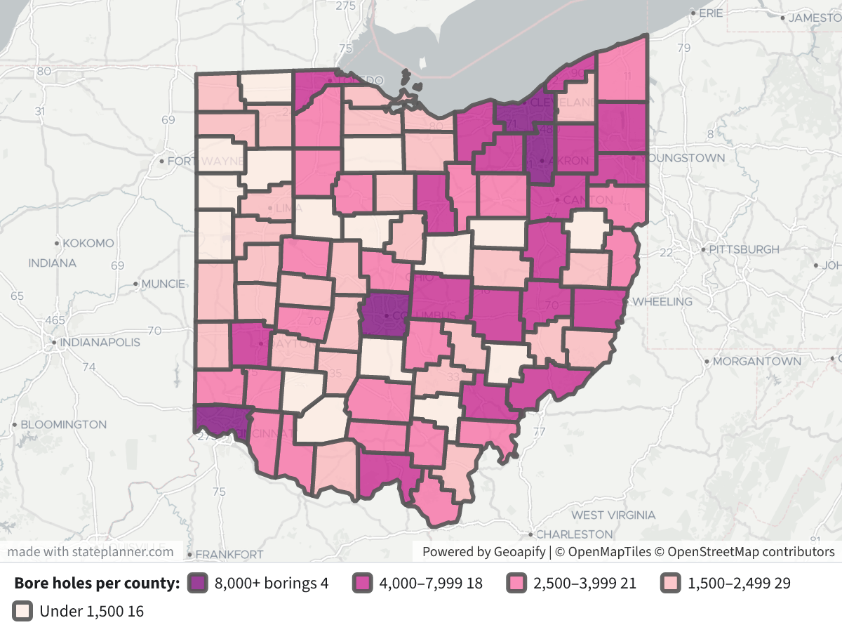
    ODOT Geotechnical Bore Holes by CountyODOT Geotechnical Bore Holes by County⬇ Image

    Map legend: each county is shaded by its number of borings. The darkest purple is 8,000 or more, then 4,000–7,999, 2,500–3,999, 1,500–2,499, and the lightest pink is under 1,500. Click a county to see its name, ODOT district, count and borings per square mile.

    Top 15 counties by number of bore holes

    CountyODOT DistrictBore holesPer sq mi
    Franklin613,77225.3
    Hamilton811,55428.0
    Summit411,38827.1
    Cuyahoga129,49020.7
    Montgomery77,10815.3
    Lucas26,04017.4
    Guernsey55,55110.5
    Athens105,54010.9
    Belmont115,47510.1
    Licking55,4087.9
    Stark45,3729.3
    Muskingum55,2967.9
    Mahoning45,05711.9
    Washington104,8667.6
    Portage44,5229.0

    What the counts show

    • Big urban counties have the most borings. Franklin, Hamilton, Summit and Cuyahoga each have about 9,500–13,800 borings, or 20–28 per square mile. Lake County is small but also dense, at 19.4 per square mile.
    • Several hilly southeastern counties also rank high. Guernsey, Athens, Belmont, Muskingum and Washington each have about 4,900–5,600.
    • Northwest and west-central Ohio have the fewest. Fulton has 250 (0.6 per square mile), Putnam 647 and Carroll 729. Most of the flat western counties have about 1,100–1,600.
    • Middle of the list: half the counties have about 2,000–3,600 borings. You can click any county on the map for its figures, or I can list all 88.

    Notes

    • A boring here is a recorded drilling location. Many projects drilled several borings close together, so the counts show how much drilling was done, not how many separate projects there were.
    • Each record has links to its project information, boring log, plan and profile documents. I can map the individual borings for one county or along one route if you want to look at a specific site.

Layers

  • …
    • …
    • …
    • …
    • …
    • …

Click anything on the map for its details.

The transcript below the answer shows every query it ran. Shapefiles of every layer, at full detail, can be downloaded in State Planner: sign up to ask your own question and export any map.

Ask your own question about Ohio

Send takes you to sign up (every feature free for 7 days, no card needed), or to sign in if you have an account. Your question will be waiting in your new chat.

Transcript

What follows is the transcript of this chat as State Planner generated it. It is here to show how the answer above was arrived at: every query State Planner ran, what each one returned, and where the data came from.

transcript.md

↑ Contents

State Planner chat · https://stateplanner.com

  • State: Ohio (OH)
  • Started: October 27, 2026, 1:35 PM UTC
  • Runtime: 36 sec
  • Status: completed
Prompt

ODOT Geotechnical Bore Hole Locations by County

Model: Anthropic: Claude Opus 5.5 (anthropic/claude-opus-5.5, via openrouter)

Response

The county name field is inconsistent (mixed case, abbreviations, typos), so I'll assign each boring to a county by its location instead.


ODOT geotechnical bore holes by county

The table holds 277,379 ODOT test borings, going back to the 1920s. Its county name field is messy, with mixed case, abbreviations like "FRA" and "HAM", and typos such as "HAMITON". To get clean counts, I placed each boring in a county by where it sits on the map, using ODOT's county outlines. That covers 277,204 borings. The other 175 fall just outside the state line, mostly along the Ohio River and Lake Erie.

ODOT Geotechnical Bore Holes by County

Map legend: each county is shaded by its number of borings. The darkest purple is 8,000 or more, then 4,000–7,999, 2,500–3,999, 1,500–2,499, and the lightest pink is under 1,500. Click a county to see its name, ODOT district, count and borings per square mile.

Top 15 counties by number of bore holes

CountyODOT DistrictBore holesPer sq mi
Franklin613,77225.3
Hamilton811,55428.0
Summit411,38827.1
Cuyahoga129,49020.7
Montgomery77,10815.3
Lucas26,04017.4
Guernsey55,55110.5
Athens105,54010.9
Belmont115,47510.1
Licking55,4087.9
Stark45,3729.3
Muskingum55,2967.9
Mahoning45,05711.9
Washington104,8667.6
Portage44,5229.0

What the counts show

  • Big urban counties have the most borings. Franklin, Hamilton, Summit and Cuyahoga each have about 9,500–13,800 borings, or 20–28 per square mile. Lake County is small but also dense, at 19.4 per square mile.
  • Several hilly southeastern counties also rank high. Guernsey, Athens, Belmont, Muskingum and Washington each have about 4,900–5,600.
  • Northwest and west-central Ohio have the fewest. Fulton has 250 (0.6 per square mile), Putnam 647 and Carroll 729. Most of the flat western counties have about 1,100–1,600.
  • Middle of the list: half the counties have about 2,000–3,600 borings. You can click any county on the map for its figures, or I can list all 88.

Notes

  • A boring here is a recorded drilling location. Many projects drilled several borings close together, so the counts show how much drilling was done, not how many separate projects there were.
  • Each record has links to its project information, boring log, plan and profile documents. I can map the individual borings for one county or along one route if you want to look at a specific site.
Exploratory Queries
Query 1 — Count bore holes by county as recorded.
   SELECT county,
          county_cd,
          odot_district,
          count(*) n
     FROM oh_geotech_bore_hole_locations
 GROUP BY 1,
          2,
          3
 ORDER BY n DESC
countycounty_cdodot_districtn
FRANKLINFRA0613502
SUMMITSUM0411272
HAMILTONHAM0811253
CUYAHOGACUY129473
MONTGOMERYMOT076940
LUCASLUC025972
ATHENSATH105495
GUERNSEYGUE055410
LICKINGLIC055402
BELMONTBEL115359
STARKSTA045345
MUSKINGUMMUS055260
MAHONINGMAH045025
WASHINGTONWAS104849
LAKELAK124493
PORTAGEPOR044478
RICHLANDRIC034419
TRUMBULLTRU044405
SCIOTOSCI094287
TUSCARAWASTUS114274
LORAINLOR034008
MEDINAMED034007
CLARKCLA073662
BUTLERBUT083650
ASHTABULAATB043620

25 out of 244 are listed here.

data/turn-1-query-1.csv

Query 2 — Count bore holes inside each county polygon, with density.
     WITH c AS (
             SELECT c.county,
                    c.odot_district,
                    c.area_sqmi,
                    s.n
               FROM oh_county c
              CROSS JOIN LATERAL (
                       SELECT count(*) n
                         FROM oh_geotech_bore_hole_locations b
                        WHERE ST_Intersects(b.geom, c.geom)
                    ) s
          )
   SELECT county,
          odot_district,
          n,
          round((n / area_sqmi)::numeric, 1) per_sqmi,
          (
             SELECT count(*)
               FROM oh_geotech_bore_hole_locations
          ) total,
          (
             SELECT count(*)
               FROM oh_geotech_bore_hole_locations
              WHERE geom IS NULL
          ) nullgeom,
          sum(n) OVER () assigned
     FROM c
 ORDER BY n DESC
countyodot_districtnper_sqmitotalnullgeomassigned
FRANKLIN61377225.32773790277204
HAMILTON81155428.02773790277204
SUMMIT41138827.12773790277204
CUYAHOGA12949020.72773790277204
MONTGOMERY7710815.32773790277204
LUCAS2604017.42773790277204
GUERNSEY5555110.52773790277204
ATHENS10554010.92773790277204
BELMONT11547510.12773790277204
LICKING554087.92773790277204
STARK453729.32773790277204
MUSKINGUM552967.92773790277204
MAHONING4505711.92773790277204
WASHINGTON1048667.62773790277204
PORTAGE445229.02773790277204
LAKE12449319.42773790277204
RICHLAND344538.92773790277204
TRUMBULL444397.02773790277204
SCIOTO943317.02773790277204
TUSCARAWAS1142817.52773790277204
LORAIN341308.42773790277204
MEDINA340889.72773790277204
BUTLER838068.12773790277204
CLARK737409.32773790277204
ASHTABULA436335.12773790277204

25 out of 88 are listed here.

data/turn-1-query-2.csv

Map Layer Queries
Bore holes per county — colored by "cls": 8,000+ borings (#7a0177), 4,000–7,999 (#c51b8a), 2,500–3,999 (#f768a1), 1,500–2,499 (#fbb4b9), Under 1,500 (#feebe2)
   SELECT c.geom,
          initcap(c.county) AS "County",
          c.odot_district AS "ODOT District",
          s.n AS "Bore holes",
          round((s.n / c.area_sqmi)::numeric, 1) AS "Per sq mi",
          CASE
                    WHEN s.n >= 8000 THEN 'a'
                    WHEN s.n >= 4000 THEN 'b'
                    WHEN s.n >= 2500 THEN 'c'
                    WHEN s.n >= 1500 THEN 'd'
                    ELSE 'e'
          END AS cls
     FROM oh_county c
    CROSS JOIN LATERAL (
             SELECT count(*) n
               FROM oh_geotech_bore_hole_locations b
              WHERE ST_Intersects(b.geom, c.geom)
          ) s

Picture: maps/turn-1-bore-holes-by-county.png

Used Data Sets

data/turn-1-query-1.csv

↑ Contents
countycounty_cdodot_districtn
FRANKLINFRA0613502
SUMMITSUM0411272
HAMILTONHAM0811253
CUYAHOGACUY129473
MONTGOMERYMOT076940
LUCASLUC025972
ATHENSATH105495
GUERNSEYGUE055410
LICKINGLIC055402
BELMONTBEL115359
STARKSTA045345
MUSKINGUMMUS055260
MAHONINGMAH045025
WASHINGTONWAS104849
LAKELAK124493
PORTAGEPOR044478
RICHLANDRIC034419
TRUMBULLTRU044405
SCIOTOSCI094287
TUSCARAWASTUS114274
LORAINLOR034008
MEDINAMED034007
CLARKCLA073662
BUTLERBUT083650
ASHTABULAATB043620
WAYNEWAY033521
COLUMBIANACOL113514
ROSSROS093434
CLERMONTCLE083318
WOODWOO023311
ASHLANDASD033309
WARRENWAR083307
JEFFERSONJEF113173
LAWRENCELAW093135
DELAWAREDEL063029
MEIGSMEG102750
LOGANLOG072621
FAIRFIELDFAI052581
PIKEPIK092521
HANCOCKHAN012510
WYANDOTWYA012500
JACKSONJAC092490
ALLENALL012476
BROWNBRO092433
MIAMIMIA072380
NOBLENOB102339
ADAMSADA092298
FAYETTEFAY082135
UNIONUNI062130
MORROWMRW062122
GALLIAGAL102117
SANDUSKYSAN022117
WILLIAMSWIL022071
MONROEMOE102061
GREENEGRE072060
GEAUGAGEA122026
HURONHUR032008
SHELBYSHE072006
ERIEERI032003
HARRISONHAS111941
AUGLAIZEAUG011940
DEFIANCEDEF021915
HOCKINGHOC101807
COSHOCTONCOS051774
PREBLEPRE071702
PERRYPER051688
MADISONMAD061634
DARKEDAR071586
CRAWFORDCRA031585
OTTAWAOTT021576
CHAMPAIGNCHP071555
HENRYHEN021507
SENECASEN021491
HIGHLANDHIG091434
CLINTONCLI081430
KNOXKNO051357
HARDINHAR011303
PICKAWAYPIC061276
VAN WERTVAN011246
MERCERMER011170
VINTONVIN101153
MARIONMAR061142
MORGANMRG101140
HOLMESHOL111074
PAULDINGPAU011074
CARROLLCAR11717
PUTNAMPUT01646
WarrenWAR8281
FULTONFUL02249
195
HAMILTONHAM8154
FRAFRA6131
BUTLERBUT8123
LORAINLOR3119
BelmontBEL11116
FRANKLINFRA6114
SUMMITSUM4112
MOTMOT7110
GuernseyGUE0591
AshlandASD0378
CLARKCLA776
HAMHAM876
GalliaGAL1062
MONTGOMERYMOT761
ColumbianaCOL1161
GUERNSEYGUE559
MedinaMED0355
WOOWOO250
HamiltonHAM0850
PORTAGEPOR447
CLERMONTCLE847
UNI0644
BROBRO939
TRUMBULLTRU436
ASHLANDASD335
ROSSROS933
RICHLANDRIC333
LoganLOG0732
ATHATH1029
MuskingumMUS0528
BUTBUT826
STARKSTA426
HolmesHOL1125
OTTOTT224
MIAMIA724
LUCLUC224
WARRENWAR823
MEDINAMED321
MEGMEG1020
FAYFAY0819
FairfieldFAI0519
CuyahogaCUY1219
MAHONINGMAH419
LAWLAW918
PikePIK0917
BROWNBRO917
SCISCI916
WashingtonWAS1015
FAIRFIELDFAI515
HAMITONHAM0814
BrownBRO0914
HarrisonHAS1114
SciotoSCI0913
ClintonCLI0813
HIGHIG913
ADAADA912
MorganMRG1012
LUCLUC112
PickawayPIC0612
NobleNOB1011
PauldingPAU0111
FRA0611
MeigsMEG1011
ERIEERI310
ALLALL110
HANHAN110
AthensATH1010
ROSROS910
MADISONMAD610
HENHEN210
MADMAD610
LickingLIC0510
MONROEMOE119
GreeneGRE079
DARKEDAR79
WARWAR89
ASHTABULAATB49
SCIOTOSCI99
AthensATH8
MIAMIMIA78
CarrollCAR118
CRAWFORDCRA38
JACKSONJAC98
MeigsMEG8
VintonVIN107
LawrenceLAW097
JeffersonJEF117
HURONHUR37
RossROS097
MonroeMOE107
SANSAN27
MRGMRG107
AUGAUG017
FRAFRA066
JacksonJAC096
WILWIL26
PerryPER056
PREPRE076
CLECLE66
LOGANLOG76
NOBNOB106
AdamsADA096
SCI096
KNOXKNO55
MonroeMOE5
WarrenWAR085
HighlandHIG095
ERIERI25
WOODLUC025
WarrenBUT85

The first 200 of 244 rows.

data/turn-1-query-2.csv

↑ Contents
countyodot_districtnper_sqmitotalnullgeomassigned
FRANKLIN61377225.32773790277204
HAMILTON81155428.02773790277204
SUMMIT41138827.12773790277204
CUYAHOGA12949020.72773790277204
MONTGOMERY7710815.32773790277204
LUCAS2604017.42773790277204
GUERNSEY5555110.52773790277204
ATHENS10554010.92773790277204
BELMONT11547510.12773790277204
LICKING554087.92773790277204
STARK453729.32773790277204
MUSKINGUM552967.92773790277204
MAHONING4505711.92773790277204
WASHINGTON1048667.62773790277204
PORTAGE445229.02773790277204
LAKE12449319.42773790277204
RICHLAND344538.92773790277204
TRUMBULL444397.02773790277204
SCIOTO943317.02773790277204
TUSCARAWAS1142817.52773790277204
LORAIN341308.42773790277204
MEDINA340889.72773790277204
BUTLER838068.12773790277204
CLARK737409.32773790277204
ASHTABULA436335.12773790277204
WARREN836288.92773790277204
COLUMBIANA1135656.72773790277204
WAYNE335246.32773790277204
ROSS934855.02773790277204
ASHLAND334228.02773790277204
CLERMONT833687.32773790277204
WOOD233615.42773790277204
JEFFERSON1131797.82773790277204
LAWRENCE931636.92773790277204
DELAWARE630296.62773790277204
MEIGS1027896.52773790277204
LOGAN726625.72773790277204
FAIRFIELD526155.12773790277204
PIKE925475.72773790277204
HANCOCK125184.72773790277204
BROWN925035.12773790277204
JACKSON925035.92773790277204
WYANDOT125006.12773790277204
ALLEN124896.12773790277204
MIAMI724155.92773790277204
NOBLE1023625.82773790277204
ADAMS923164.02773790277204
GALLIA1021804.62773790277204
UNION621775.02773790277204
FAYETTE821545.32773790277204
SANDUSKY221235.12773790277204
MORROW621225.22773790277204
MONROE1020824.62773790277204
WILLIAMS220794.92773790277204
GREENE720695.02773790277204
GEAUGA1220295.02773790277204
HURON320184.12773790277204
ERIE320137.82773790277204
SHELBY720074.92773790277204
HARRISON1119574.82773790277204
AUGLAIZE119444.82773790277204
DEFIANCE219154.62773790277204
HOCKING1018094.32773790277204
COSHOCTON517813.12773790277204
PREBLE717084.02773790277204
PERRY516974.12773790277204
MADISON616613.62773790277204
OTTAWA215976.02773790277204
DARKE715952.72773790277204
CRAWFORD315934.02773790277204
CHAMPAIGN715553.62773790277204
HENRY215193.62773790277204
SENECA214912.72773790277204
HIGHLAND914522.62773790277204
CLINTON814473.52773790277204
KNOX513612.62773790277204
HARDIN113042.82773790277204
PICKAWAY612932.62773790277204
VAN WERT112483.02773790277204
MERCER111732.52773790277204
VINTON1011632.82773790277204
MORGAN1011602.82773790277204
MARION611422.82773790277204
HOLMES1110982.62773790277204
PAULDING110862.62773790277204
CARROLL117291.82773790277204
PUTNAM16471.32773790277204
FULTON22500.62773790277204

88 rows.

provenance/oh_county.md

↑ Contents

Provenance: oh_county

This file describes how the rows in PostgreSQL table oh_county were obtained from an external source: where they were fetched and how fields were renamed and typed. Field meanings are in the mapping table below.

Identity
Pipeline (TIMS family)

Ohio DOT TIMS publishes this layer on the TIMS data page. The catalog behind that page is GET https://tims.dot.state.oh.us/tims/api/glossary. Each entry names a MapServer layer URL.

Data is fetched as GeoJSON from that layer's REST query endpoint (where=1=1, outFields=*, outSR=4326, f=geojson), paginated with resultOffset / resultRecordCount. GeoJSON was chosen over the portal's CSV/SHP/GDB/KMZ exports because it keeps full attribute names, keeps geometry, and loads into PostGIS via ST_GeomFromGeoJSON.

Esri field names become lowercase snake_case PostgreSQL columns (non [a-z0-9_] → _). Dates stored as Esri epoch-milliseconds become timestamptz. Geometry is ST_SetSRID(ST_GeomFromGeoJSON(…), 4326), wrapped in ST_Multi when the table's stored type is Multi*. Esri shape-area / shape-length system fields are dropped.

The same MapServer query is used whenever the table is refreshed.

Field → column mapping
Source fieldColumnEsri typeDescription
OBJECTIDobjectidesriFieldTypeOID
COUNTY_CDcounty_cdesriFieldTypeStringThe 3-letter code of the county within Ohio (88 counties total) [ODOT]
COUNTYcountyesriFieldTypeStringCounty name [ODOT]
COUNTY_SEATcounty_seatesriFieldTypeStringCity that serves as the County seat [ODOT]
ODOT_DISTRICTodot_districtesriFieldTypeSmallIntegerFrom 1-12 plus Central Office – the counties are grouped into districts in Ohio for ease of maintenance and funding [ODOT]
FIPS_COUNTY_CDfips_county_cdesriFieldTypeStringFIPS County Code (Federal Information Processing Standard) [ODOT]
POP_2020pop_2020esriFieldTypeInteger
POP_2010pop_2010esriFieldTypeIntegerCounty population in 2010
POP_2000pop_2000esriFieldTypeIntegerCounty population in 2000
POP_1990pop_1990esriFieldTypeIntegerCounty population in 1990
STATE_PLANE_ZONEstate_plane_zoneesriFieldTypeStringState plane zone in which the county falls, N - North or S - South
ELEVATION_MAXIMUMelevation_maximumesriFieldTypeSmallIntegerMaximum elevation within the County boundaries
ELEVATION_MINIMUMelevation_minimumesriFieldTypeSmallIntegerMinimum elevation within the County boundaries
LAT_NORTH_DDlat_north_ddesriFieldTypeDouble
LAT_SOUTH_DDlat_south_ddesriFieldTypeDouble
LONG_EAST_DDlong_east_ddesriFieldTypeDouble
LONG_WEST_DDlong_west_ddesriFieldTypeDouble
AREA_SQMIarea_sqmiesriFieldTypeDouble
AREA_IDarea_idesriFieldTypeInteger
(feature geometry)geomST_Multi(ST_SetSRID(ST_GeomFromGeoJSON(…), 4326))Feature geometry, WGS84
Geometry
  • SRID 4326 (WGS84). GIST index on geom.
  • Empty / null geometries stored as SQL NULL.

provenance/oh_geotech_bore_hole_locations.md

↑ Contents

Provenance: oh_geotech_bore_hole_locations

This file describes how the rows in PostgreSQL table oh_geotech_bore_hole_locations were obtained from an external source: where they were fetched and how fields were renamed and typed. Field meanings are in the mapping table below.

Identity
Pipeline (TIMS family)

Ohio DOT TIMS publishes this layer on the TIMS data page. The catalog behind that page is GET https://tims.dot.state.oh.us/tims/api/glossary. Each entry names a MapServer layer URL.

Data is fetched as GeoJSON from that layer's REST query endpoint (where=1=1, outFields=*, outSR=4326, f=geojson), paginated with resultOffset / resultRecordCount. GeoJSON was chosen over the portal's CSV/SHP/GDB/KMZ exports because it keeps full attribute names, keeps geometry, and loads into PostGIS via ST_GeomFromGeoJSON.

Esri field names become lowercase snake_case PostgreSQL columns (non [a-z0-9_] → _). Dates stored as Esri epoch-milliseconds become timestamptz. Geometry is ST_SetSRID(ST_GeomFromGeoJSON(…), 4326), wrapped in ST_Multi when the table's stored type is Multi*. Esri shape-area / shape-length system fields are dropped.

The same MapServer query is used whenever the table is refreshed.

Field → column mapping
Source fieldColumnEsri typeDescription
OBJECTIDobjectidesriFieldTypeOID
NLFIDnlfidesriFieldTypeStringPrimary key field that is the basis for identifying unique roadway segments in ODOT's graphic roadway network. The attribute is made up of seven components that describe administrative and other characteristics related to a route segment; Positions (1) - Jurisdiction, (2 thru 4) - County Code, (5 thru 6) - Route Type, (7 thru 11) - Route Number, (12) - Extension Code, (13) - Description Code, (14) - Direction Code; For further definitions of codes, please refer to the Roadway Information Manual
CTL_BEGIN_NBRctl_begin_nbresriFieldTypeDoubleCounty logpoint number along the route on which the boring is located
ODOT_DISTRICTodot_districtesriFieldTypeStringODOT District of the borehole location
COUNTYcountyesriFieldTypeStringCounty of the borehole location
COUNTY_CDcounty_cdesriFieldTypeStringThe 3-letter code of the county within Ohio (88 counties total)
ROUTE_TYPEroute_typeesriFieldTypeStringTwo letter code indicating the basic transportation grouping or system that the route belongs to - third component of the NLFID
ROUTE_NBRroute_nbresriFieldTypeStringRoute number associated with the section of the route
ROUTE_SUFFIXroute_suffixesriFieldTypeStringSingle letter used with the route number in local and municipal systems to guarantee uniqueness; For further definitions of codes, please refer to the Roadway Information Manual
PERP_DATEperp_dateesriFieldTypeDateCalendar year in which a RI event occurs (like new constructions, abandoning of roads, annexations, increase in speed limit, and so on) on a roadway and is recorded in ODOT’s RI database.
LATITUDE_DD_BEGINlatitude_dd_beginesriFieldTypeDoubleDecimal Degree Latitude coordinate
LONGITUDE_DD_BEGINlongitude_dd_beginesriFieldTypeDoubleDecimal Degree Longitude coordinate
SUB_BATCHsub_batchesriFieldTypeStringDirectory name of the relative directory structure for the location of the project related documents
STATIONstationesriFieldTypeStringBorehole location stationing as recorded in the original project documents
OFFSEToffset_esriFieldTypeDoubleBorehole location offset as recorded in the original project documents
DIRECTIONdirectionesriFieldTypeStringBorehole location offset direction as recorded in the original project documents
BORING_IDboring_idesriFieldTypeStringBorehole location name as recorded in the original project documents
CONFconfesriFieldTypeSmallIntegerConfidence level associated with the position of the features on the map
MISCmiscesriFieldTypeStringMiscellaneous data associated with the project
ALIASaliasesriFieldTypeStringAlternate route name
DATA_URLdata_urlesriFieldTypeString
LOG_URLlog_urlesriFieldTypeStringLink to the document for the borehole log as stored in the document management system
PLAN_URLplan_urlesriFieldTypeStringLink to the document for the boring plan as stored in the document management system
PROFILE_URLprofile_urlesriFieldTypeStringLink to the document for the profile as stored in the document management system
DIGGS_URLdiggs_urlesriFieldTypeStringLink to the DIGGS file (native XML format) for the project
(feature geometry)geomST_SetSRID(ST_GeomFromGeoJSON(…), 4326)Feature geometry, WGS84
Geometry
  • SRID 4326 (WGS84). GIST index on geom.
  • Empty / null geometries stored as SQL NULL.

© 2026 State Planner