transcript.md
↑ ContentsState Planner chat · https://stateplanner.com
- State: Ohio (OH)
- Started: October 22, 2026, 4:27 PM UTC
- Runtime: 29 sec
- Status: completed
Prompt
Ohio CORS Network: ODOT RTK Reference Stations by County
Model: Anthropic: Claude Opus 5.5 (anthropic/claude-opus-5.5, via openrouter)
Response
ODOT CORS network: RTK reference stations by county
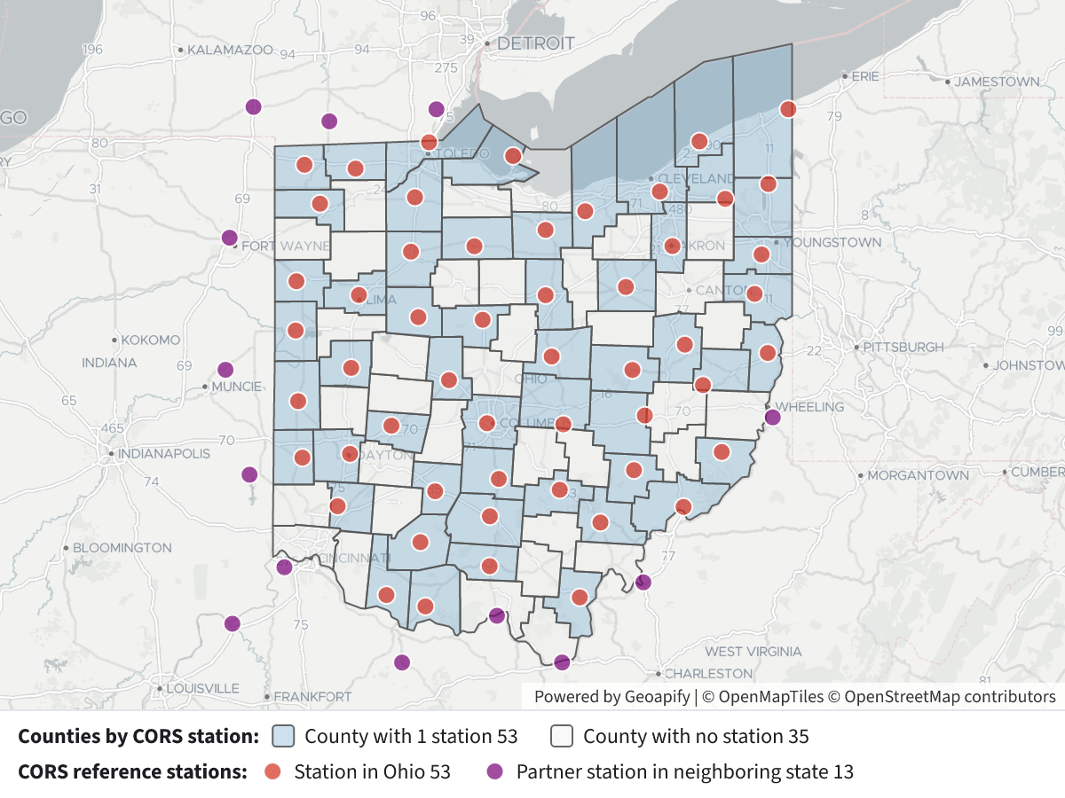
ODOT's CORS (Continuously Operating Reference Station) network has 66 stations (TIMS layer, last updated 2025-08-14). They provide the GNSS corrections used for survey-grade positioning on ODOT projects.
- 53 stations are inside Ohio. No county has more than one, so 53 of the 88 counties have a station and 35 have none.
- 13 stations are in neighboring states. They are tied into the network to cover the border areas: 3 in Indiana, 4 in Kentucky, 3 in Michigan and 3 in West Virginia.
- Who maintains them: ODOT maintains 51 of the 53 Ohio stations. The City of Dayton maintains OHDT and the City of Bowling Green maintains BGOH. The out-of-state stations are kept by ODOT, INDOT, KTC, MDOT or WVDOH.
- Where they sit: Most are at ODOT county garages, district headquarters or county engineer offices. A few are at universities (Ohio University, Akron, Marshall), a school, a jail and an airport on South Bass Island.
Ohio counties with a CORS station (one each)
| County | Station | Site |
|---|---|---|
| Adams | OHAD | West Union water department |
| Allen | OHAL | Allen Co. Engineer |
| Ashtabula | OHAB | ODOT I-90 travel information center |
| Athens | STKR | Ohio University, Stocker Center |
| Brown | GRTN | ODOT garage |
| Clark | OHCL | ODOT garage |
| Columbiana | OHCB | County jail |
| Coshocton | OHCS | ODOT garage |
| Cuyahoga | GARF | ODOT District 12 HQ |
| Darke | OHDR | Sheriff's garage |
| Defiance | OHDF | County Engineer |
| Fayette | OHFY | ODOT garage |
| Franklin | COLB | ODOT Central Office garage |
| Fulton | OHFN | Wauseon school bus garage |
| Gallia | GALP | ODOT garage |
| Geauga | OHGA | County Engineer |
| Hancock | OHHA | County Engineer outpost |
| Hardin | KNTN | ODOT garage |
| Harrison | FREO | Freeport outpost |
| Highland | OHHI | County Engineer |
| Hocking | OHHO | ODOT garage |
| Huron | OHHU | ODOT garage |
| Jefferson | OHJF | ODOT garage |
| Knox | MTVR | ODOT garage |
| Lake | OHLA | County Engineer |
| Licking | OHLI | ODOT District 5 HQ |
| Lorain | OHLO | ODOT garage |
| Lucas | OHLC | County Engineer |
| Mahoning | OHMN | ODOT garage |
| Marion | OHMA | ODOT garage |
| Mercer | OHMR | ODOT garage |
| Monroe | OHME | ODOT garage |
| Montgomery | OHDT | City of Dayton |
| Morgan | MCON | ODOT garage |
| Muskingum | OHJG | John Glenn High School |
| Ottawa | OHSB | South Bass Island Airport |
| Pickaway | OHPI | Pickaway SWCD |
| Pike | PKTN | ODOT garage |
| Preble | OHPR | ODOT garage |
| Richland | OHRI | ODOT garage |
| Ross | OHRS | ODOT garage |
| Seneca | TIFF | ODOT garage |
| Shelby | SIDN | ODOT garage |
| Summit | OHZP | University of Akron |
| Trumbull | GUST | Gustavus outpost |
| Tuscarawas | OHTS | ODOT District 11 HQ |
| Union | OHUN | Marysville city garage |
| Van Wert | OHVA | ODOT garage |
| Warren | LEBA | ODOT District 8 HQ |
| Washington | OHWS | ODOT garage |
| Wayne | OHWY | ODOT garage |
| Williams | OHWI | ODOT garage |
| Wood | BGOH | Bowling Green (city) |
Stations in neighboring states: INAB, INFW and INLB (Indiana); KYBO, KYBU, KYSS and KYTI (Kentucky); MICW, MIKS and MIMO (Michigan); WVHU, WVRA and WVSH (West Virginia).
Map legend
- Blue counties: have one CORS station.
- Light gray counties: have no station inside the county.
- Red dots: stations in Ohio.
- Purple dots: partner stations in neighboring states.
- Clicking a station shows its name, site, maintainer, year built, receiver and antenna models, ellipsoid height and its link to the National Geodetic Survey.
Having no station in the county doesn't mean a county lacks RTK coverage. The stations are spread out so each one serves a radius that reaches into nearby counties. I can add distance rings around each station (for example 30 or 40 km) to show how much of the state is covered.
Exploratory Queries
Query 1 — Count CORS stations per county via spatial join, including stations outside Ohio.
   SELECT coalesce(c.name, '(outside Ohio)') county,
          count(*) n,
          string_agg(
          s.station_name || ' (' || s.location || ')',
          '; '
           ORDER BY s.station_name
          ) stations,
          string_agg(DISTINCT s.station_maintained_by, ', ') maint
     FROM oh_odot_cors_network s
LEFT JOIN oh_census_counties c ON ST_Intersects(c.geom, s.geom)
 GROUP BY 1
 ORDER BY n DESC,
          1
| county | n | stations | maint |
|---|---|---|---|
| (outside Ohio) | 13 | INAB (Indiana Albany); INFW (Indiana Fort Wayne); INLB (Indiana Liberty); KYBO (Boone County (KY) ); KYBU (Kentucky General Butler SRP); KYSS (Kentucky South Shore); KYTI (Kentucky Hwy Dist 9 ); MICW (Michigan Coldwater); MIKS (Michigan Hudson); MIMO (Michgan Monroe); WVHU (Marshall Univ (Huntington WV)); WVRA (Ravenswood WV ); WVSH (West Virginia Sherrard) | INDOT, KTC, MDOT, ODOT, WVDOH |
| Adams County | 1 | OHAD (West Union, Ohio Water Department) | ODOT |
| Allen County | 1 | OHAL (Allen Co Engineer's office) | ODOT |
| Ashtabula County | 1 | OHAB (ATB Co. ODOT I-90 TIC) | ODOT |
| Athens County | 1 | STKR (Ohio University, Stocker Center) | ODOT |
| Brown County | 1 | GRTN (Brown Co. ODOT Garage) | ODOT |
| Clark County | 1 | OHCL (Clark Co. ODOT Garage) | ODOT |
| Columbiana County | 1 | OHCB (Columbiana Co.Jail) | ODOT |
| Coshocton County | 1 | OHCS (Coshocton Co. ODOT Garage) | ODOT |
| Cuyahoga County | 1 | GARF (ODOT Dist 12 HQ (Garage Bld)) | ODOT |
| Darke County | 1 | OHDR (Darke Co Sheriff Garage) | ODOT |
| Defiance County | 1 | OHDF (Defiance Co. Engineer's Office) | ODOT |
| Fayette County | 1 | OHFY (Fayette Co. ODOT Garage) | ODOT |
| Franklin County | 1 | COLB (ODOT Central Office Garage) | ODOT |
| Fulton County | 1 | OHFN (City of Wauseon School bus garage) | ODOT |
| Gallia County | 1 | GALP (Gallia Co. ODOT Garage) | ODOT |
| Geauga County | 1 | OHGA (Geauga Co Engineer ) | ODOT |
| Hancock County | 1 | OHHA (Hancock Co Engineer outpost) | ODOT |
| Hardin County | 1 | KNTN (Hardin Co. ODOT Garage) | ODOT |
| Harrison County | 1 | FREO (Harrison Co (Freeport Outpost)) | ODOT |
| Highland County | 1 | OHHI (Highland Co. Engineer) | ODOT |
| Hocking County | 1 | OHHO (Hocking Co. ODOT Garage) | ODOT |
| Huron County | 1 | OHHU (ODOT Huron Co. ODOT Garage) | ODOT |
| Jefferson County | 1 | OHJF (Jefferson Co. ODOT Garage) | ODOT |
| Knox County | 1 | MTVR (Knox Co. ODOT Garage) | ODOT |
25 out of 54 are listed here.
Map Layer Queries
Counties by CORS station — colored by "cat": County with 1 station (#74a9cf), County with no station (#eeeeee)
   SELECT c.geom,
          c.name AS "County",
          count(s.objectid) AS "CORS stations",
          CASE
                    WHEN count(s.objectid) > 0 THEN 'has'
                    ELSE 'none'
          END AS cat
     FROM oh_census_counties c
LEFT JOIN oh_odot_cors_network s ON ST_Intersects(c.geom, s.geom)
 GROUP BY c.geom,
          c.name
Picture: maps/turn-1-cors-stations-by-county.png
CORS reference stations — colored by "cat": Station in Ohio (#d7301f), Partner station in neighboring state (#7a0177)
   SELECT s.geom,
          s.station_name AS "Station",
          s.location AS "Location",
          s.station_maintained_by AS "Maintained by",
          s.year_built AS "Year built",
          s.receiver_model AS "Receiver",
          s.antenna_model AS "Antenna",
          round(s.eliptical_height::numeric, 1) AS "Ellipsoid height(m)",
          s.station_link AS "NGS link",
          CASE
                    WHEN EXISTS (
                       SELECT 1
                         FROM oh_census_counties c
                        WHERE ST_Intersects(c.geom, s.geom)
                    ) THEN 'oh'
                    ELSE 'out'
          END AS cat
     FROM oh_odot_cors_network s
Picture: maps/turn-1-cors-stations-by-county.png
Used Data Sets
oh_census_counties— last synced 2026-09-26 · 88 rowsoh_odot_cors_network— last synced 2026-09-27 · 66 rows