
Ohio · October 17, 2026
Otway 10-Mile Land Cover
This is a real answer State Planner produced from Ohio’s public data.
Start for free to ask your own version of this question, or anything else about your state.
Find a town with a population less than 50,000 that has the most undeveloped land within a 10-mile radius around it. Show its land cover on the map.
I’ll treat “town” as an incorporated city or village with fewer than 50,000 residents, using the latest Census population estimates. I’ll measure a 10-mile radius from each town’s center and define undeveloped land as forest, farmland, grassland, shrubland, and wetlands—not water or NLCD’s developed classes, which include parks and large-lot lawns.
Otway currently leads the precise cell counts, just ahead of Midway. I’m checking every eligible town directly so the final choice doesn’t depend on the approximate block-group screening. Only land within Ohio can be counted; circles near the state line may extend beyond the available data.
Otway village is the top match
Otway, in Scioto County, has an estimated population of 88 residents in the Census Bureau’s July 2025 estimates. Its 10-mile circle contains 291.87 square miles of undeveloped land under the definition used here—about 93.5% of the circle’s mapped land area, excluding water.
I checked all 905 active incorporated Ohio cities and villages with populations below 50,000, using direct cell counts from USGS Annual NLCD 2025. Otway narrowly exceeds Midway village, at 291.69 square miles.
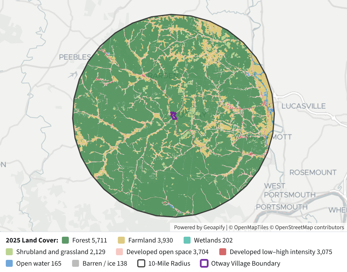 Otway 10-Mile Land Cover⬇ Image
Land cover within 10 miles of Otway, 2025
Land cover Square miles Forest 247.52 Farmland—crops, pasture and hay 38.10 Developed open space 15.28 Shrubland and grassland 5.93 Developed, low–high intensity 3.40 Open water 1.11 Barren land / ice 0.46 Wetlands 0.32 Map legend: Dark green = forest; gold = farmland; light green = shrubland and grassland; teal = wetlands; pink = developed open space; red = other developed land; blue = water; gray = barren land. The black outline marks the 10-mile circle; purple outlines Otway.
How to interpret the result
- The radius is measured from each place’s Census internal point, not outward from its municipal boundary.
- “Undeveloped” includes forest, farmland, shrubland, grassland and wetlands. It excludes water, barren land and all four developed classes—including parks and lawns classified as developed open space.
- These are 30-meter satellite land-cover classifications, not a land survey or a measure of land available for construction. Farmland counts here even though it is actively used.
- Only Ohio’s land cover is available, so portions of other towns’ circles outside Ohio were not counted. A boundary-based radius or a definition excluding farmland could produce a different winner.
Layers
- …
- …
- …
- …
- …
- …
- …
- …
- …
- …
- …
Click anything on the map for its details.
The transcript is a Word document with every query the answer ran. Shapefiles of every layer, at full detail, can be downloaded in State Planner: sign up to ask your own question and export any map.