
Ohio · September 26, 2026
NOACA $10M Safety Program Picks
This is a real answer State Planner produced from Ohio’s public data.
Start for free to ask your own version of this question, or anything else about your state.
The NOACA area around Cleveland has $10 million for safety improvements on state routes. Choose where to spend it to prevent the most fatal and serious-injury crashes, using 2021–2024 crashes and two countermeasures. The first is centerline and shoulder rumble strips at $25,000 per mile, which cut lane-departure crashes by 30% on two-lane segments posted 45 mph or higher. The second is roundabouts at $2 million each, which cut angle crashes by 60% at intersections. Rank candidates by crashes prevented per dollar, pick the best mix within the budget, and map the chosen segments and intersections with the expected crashes prevented at each.
I'll start by inspecting the key tables.
Recommended $10M program: 107 rumble-strip segments and 3 roundabouts
Cost: $9.85M. Expected result: about 48 fewer fatal and serious-injury (KSI) crashes over four years, or about 12 per year. The estimate assumes 2021–2024 crash patterns continue and the effect rates you gave (30% for rumble strips, 60% for roundabouts).
Countermeasure Sites Cost KSI crashes 2021–24 KSI prevented (4 yrs) Per year Centerline and shoulder rumble strips 107 segments, 154 mi $3.85M 141 lane-departure KSI (28 fatal) 42.3 10.6 Roundabouts 3 intersections $6.00M 10 angle KSI 6.0 1.5 Total $9.85M 48.3 12.1 Left over $0.15M 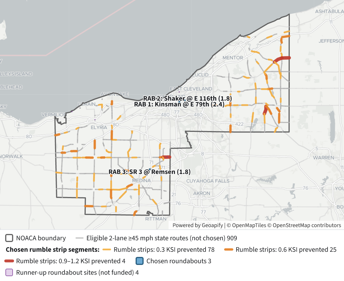 NOACA $10M Safety Program Picks⬇ Image
Why rumble strips come first
Ranked by crashes prevented per dollar, every rumble-strip segment with at least one KSI crash beats every roundabout.
- Rumble strips prevent 3.2 to 37 KSI crashes per $1M. One KSI crash on a one-mile segment gives 0.3 prevented for $25k, which works out to 12 per $1M.
- Roundabouts prevent at most 1.2 per $1M. The best intersection in the region had 4 angle KSI crashes in four years, so 2.4 prevented for $2M.
So the best mix funds every rumble-strip segment with a KSI history. The remaining $6.15M buys three roundabouts. The last $0.15M can't buy a fourth. It could pay for about 6 more miles of strips on segments with many non-KSI lane-departure crashes, but those show no KSI benefit under this measure.
Top rumble-strip segments (KSI prevented per $1M):
- SR 83, Medina County, log miles 12.2–12.8: 37.4
- SR 57, Medina County, 17.8–18.7: 25.8
- US 20, Lorain County, 1.8–2.8: 24.2
- SR 94, Medina County, 17.7–18.7: 24.2
- SR 83, Lorain County, 18.6–19.6: 24.0
The largest single benefits are SR 166 in Geauga County at log miles 6.6–8.8 (1.2 KSI prevented) and SR 303 in Medina County at 12.9–14.9 (0.9). Most of the chosen mileage is rural Geauga, Medina and Lorain counties.
The three roundabouts:
- US 422 (Kinsman Rd) at E 79th St, Cleveland: 4 angle KSI crashes, 1 of them fatal. Expected 2.4 prevented.
- SR 87 (Shaker Blvd) at E 116th St, Cleveland: 3 angle KSI crashes out of 35 angle crashes. Expected 1.8 prevented.
- SR 3 (Weymouth Rd) at Remsen Rd, Medina County: 3 angle KSI crashes out of 18 angle crashes. Expected 1.8 prevented.
The third pick was a four-way tie at 3 angle KSI crashes. I broke it by total angle crashes, since more of those would also be prevented. If you'd rather weight fatal crashes, the tie would go to US 6 (Erie Rd) at Oak Point Rd in Lorain County, which had 1 fatal crash.
Map legend
- Grey outline: the NOACA boundary.
- Light grey lines: all 470 miles of state routes that qualify for rumble strips but had no lane-departure KSI crash, so they aren't funded.
- Rumble-strip segments, colored by KSI crashes prevented over four years: yellow 0.3, orange 0.6, red 0.9–1.2.
- Blue circles: the three chosen roundabouts.
- Light purple circles: runner-up intersections that aren't funded.
Click any feature to see its route, log miles, traffic volume, crash counts, cost and expected crashes prevented.
How I defined the candidates
- State routes: SR and US routes in Cuyahoga, Geauga, Lake, Lorain and Medina counties. Interstates are excluded.
- Rumble-strip candidates: undivided two-way roads with 2 lanes and a posted limit of 45 mph or more. I joined stretches that run continuously along a route and split them into pieces of about a mile. Stretches shorter than half a mile were dropped as too short to be a practical project.
- Lane-departure crashes counted were head-on, sideswipe (meeting), fixed object, overturning and other non-collision crashes away from intersections. Crashes were matched to segments by route ID and log mile.
- Roundabout candidates: angle crashes at intersections, grouped into intersections if within 60 m of each other, keeping groups that include a state route. I dropped four intersections that already have crashes coded as a roundabout.
- Serious crashes: "KSI" means crashes coded Fatal or Serious Injury Suspected.
Caveats
- Small numbers: most segments have only 1–2 KSI crashes in four years. These are the kinds of places where serious crashes happen, not proven hotspots, and some will see fewer crashes anyway (regression to the mean).
- Urban roundabout sites: Kinsman and Shaker are dense urban intersections, likely signalized and on transit routes. Right-of-way could push the cost well past $2M, so check feasibility before committing. SR 3 at Remsen is a typical rural roundabout site.
- Not captured: the benefit counts only KSI crashes. Both treatments would also reduce less severe crashes; for example, the SR 301 segment in Lorain County at log miles 9.8–12.0 had 21 lane-departure crashes.
- Not checked: homes nearby (rumble-strip noise), bike routes, or existing rumble strips, since none of these are in the road data. Strips may already be in place on some chosen segments.
Layers
- …
- …
- …
- …
- …
- …
- …
- …
Click anything on the map for its details.
The transcript is a Word document with every query the answer ran. Shapefiles of every layer, at full detail, can be downloaded in State Planner: sign up to ask your own question and export any map.