
Ohio · September 26, 2026
Posted Bridges on Truck and Freight Networks
This is a real answer State Planner produced from Ohio’s public data.
Start for free to ask your own version of this question, or anything else about your state.
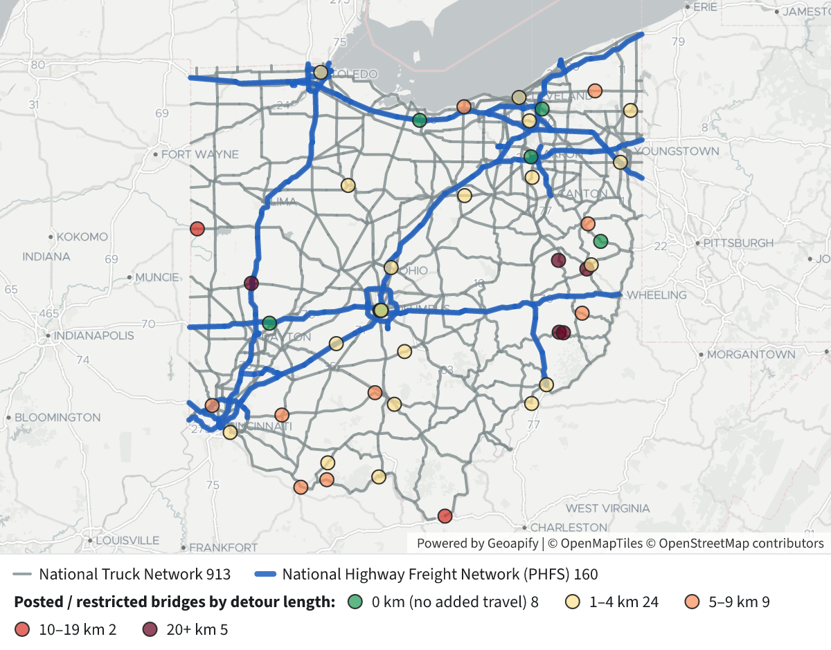
Draw the National Truck Network and the freight network, then mark every load-posted or restricted bridge on them, colored by posted detour length.
 Posted Bridges on Truck and Freight Networks⬇ Image
48 load-posted or restricted bridges carry traffic on Ohio's National Truck Network (NTN) or National Highway Freight Network (NHFN). 37 are posted for load and 11 are posted for some other restriction. 9 of the 48 are on the NHFN.
Map legend
- Grey lines: National Truck Network (913 segments: all Interstates plus the former Federal Aid Priority routes)
- Thick blue lines: National Highway Freight Network, which in Ohio is entirely the Primary Highway Freight System (160 segments)
- Bridge dots, colored by detour length (the extra distance vehicles would travel if the bridge closed, recorded in km):
- 🟢 0 km: 8 bridges
- 🟡 1–4 km: 24 bridges
- 🟠 5–9 km: 9 bridges
- 🔴 10–19 km: 2 bridges
- 🟤 20+ km: 5 bridges
Click a dot to see its structure number, the road it carries and what it crosses, its status, its load capacity as a percent of Ohio's legal load, its detour in km and miles, its daily traffic and which network it is on.
Longest detours. All of these are rural state routes on the NTN, not the NHFN, and all are load-posted:
Bridge County Detour SR 800 over Stillwater Creek Tuscarawas 39 km (~24 mi) SR 78 over Middle Creek Monroe 38 km SR 78 over Pryors Run Monroe 38 km SR 22 over a branch of Brushy Fork Harrison 23 km US 36 over the Great Miami River Miami 22 km (13,300 daily vehicles) SR 29 over the Wabash River Mercer 17 km SR 775 over the Ohio River Lawrence 15 km On the freight network (NHFN). Most detours are short (0–4 km) because these are urban or Interstate structures:
- Several I-70/I-71 structures in downtown Columbus
- I-71 over Thompson Creek (Madison County)
- I-77 over SR 7 (Washington County)
- US 24 over I-75 (Toledo)
- The Ohio Turnpike (I-80) in Erie County
- Two Cleveland city-street bridges over the Cuyahoga River (River Road and West 3rd Street)
How I defined it
- "Posted or restricted" means the bridge's open/posted/closed status (NBI item 41) is P (posted for load) or R (posted for another restriction). I left out closed bridges and bridges where posting is only recommended.
- "On the network" means the bridge carries the network route. I matched each bridge's route ID and log mile to the network segments' route ID and mile range, without the final direction character, so bridges on either direction of a divided highway count. I didn't use distance on the map because that would also catch local-road overpasses and underpasses. For comparison, 50 other posted bridges are within 30 m of the networks without carrying them.
- I removed two records (Berkshire Rd over I-71 and Woodland Cemetery Rd over US 52). They are coded with the route passing underneath, but they actually carry local roads, so their postings don't limit trucks on the network.
- The detour length is the figure recorded in the inventory. A 0 means closing the bridge would add no distance, for example because a parallel structure or at-grade alternative exists. It is not a routed truck detour.
I can also add bridges where posting is recommended (status B) or closed bridges (K), filter to one district, or rank the list by daily traffic × detour to show which restrictions cost trucks the most.
Layers
- …
- …
- …
- …
- …
- …
- …
- …
Click anything on the map for its details.
The transcript is a Word document with every query the answer ran. Shapefiles of every layer, at full detail, can be downloaded in State Planner: sign up to ask your own question and export any map.