
Ohio · September 28, 2026
ODOT Approved Speed Zones by Posted Limit
This is a real answer State Planner produced from Ohio’s public data.
Start for free to ask your own version of this question, or anything else about your state.
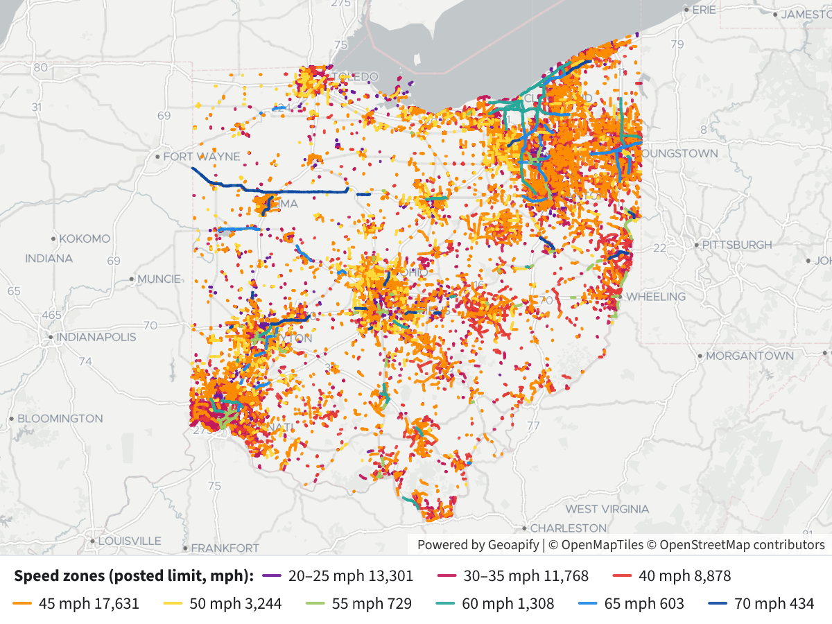
Map posted speed limits on ODOT roads in Ohio, colored by limit, with a legend.
The map shows 57,896 ODOT speed zones currently in effect, about 14,800 miles in total, colored by posted limit.
 ODOT Approved Speed Zones by Posted Limit⬇ Image
Legend: posted limit, in mph
Color Limit Zones Approx. miles Purple 20–25 13,348 2,560 Magenta 30–35 11,860 2,540 Red 40 8,945 2,590 Orange 45 17,771 5,050 Yellow 50 3,275 945 Light green 55 732 193 Teal 60 1,313 471 Blue 65 608 237 Navy 70 439 195 Click a segment to see its route, street, county, authority, status and approval date.
What the map does and doesn't show:
- Source: ODOT's Speed Zones inventory. It only lists places where ODOT approved a limit different from the default speed set by state law.
- Roads without a zone aren't drawn: Most rural two-lane roads (55 mph by default) and most interstates don't have a zone record, so they don't appear. The map is not a complete picture of every road's limit.
- What I kept: zones with status "Approved" or "Active", no withdrawal date and a valid speed.
- What I dropped: withdrawn, deleted, under-review and denied requests, plus about 8,400 records with a speed of 0 or blank.
- Which roads: Interstate, US, state, county, township and municipal routes are all included, because ODOT approves zones on all of them. Most zones are on county and township roads, and the orange 45 mph zones cover the most miles.
If you want only the state highway system (interstate, US and state routes), I can filter to those. I can also add the 55 mph default roads from the Road Inventory, which would give fuller coverage but those limits would be inferred rather than recorded.
Layers
- …
- …
- …
- …
- …
- …
- …
- …
- …
- …
Click anything on the map for its details.
The transcript is a Word document with every query the answer ran. Shapefiles of every layer, at full detail, can be downloaded in State Planner: sign up to ask your own question and export any map.